(May 7, 2019 / Author: Tim Bondy) On May 1, 2019, I rode the Boise, Idaho area Military Reserve “Ridge to Rivers” trails for the first time in my life. Boise has a first-class trail system on the fringes of downtown that spread widely up and out along the foothills. It was fun, exhausting and I plan to return a few more times this year.
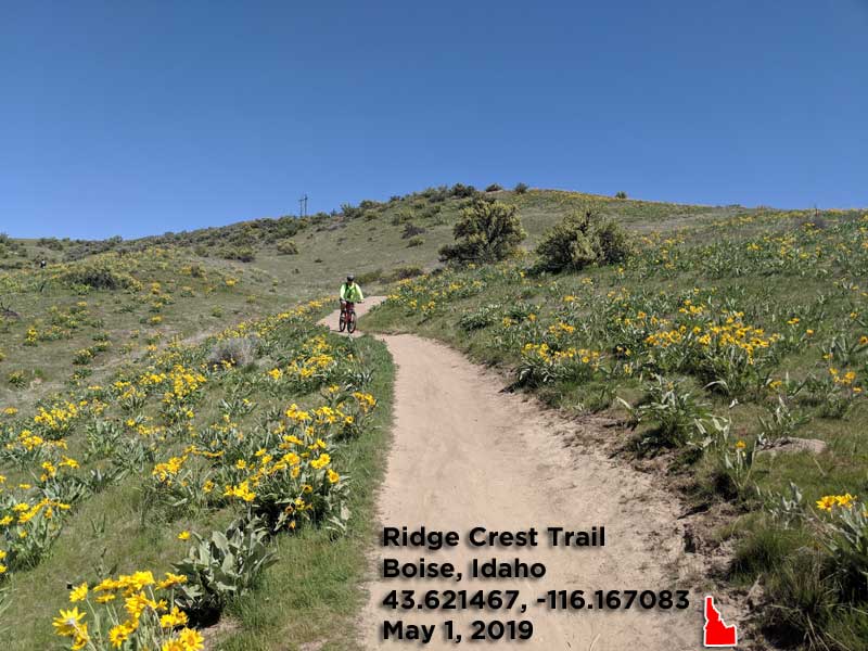
Featured Image Info: 43.621467, -116.167083 / Link at https://photos.app.goo.gl/bTii1sQmjj1ZSHvz9
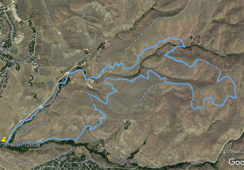
The Ridge to Rivers trail system is extensive so some research must go into your first few rides in the Boise Foothills if you want a hassle-free ride. Taking a map, whether it’s digital or paper is recommended so you don’t head off in the wrong direction and end up at the trailhead 15 minutes after you start.
The scenery is pure “southern Idaho.” Treeless ridges, brush/tree filled canyons and vistas that go on forever. For the most part, it wide open and as far from a claustrophobic and closed in ride as you can experience.
“Crowds on the Boise Foothills trails is the only downside and they’re not all that crowded … I suppose.” ~ Tim Bondy
For me, the crowds were a little difficult to takes. This is my third season of riding regularly in southern Idaho. During my rides near the tiny town of Mountain Home, I occasionally see other people or vehicles but many times I’m completely alone from the trailhead and back again. There should be no doubt you will encounter mountain bikers, hikers,and trail runners on the Boise area trails. But the trails are top-of-the-line and first class.
Military Reserve Ride Stats for the 1 May 2019 MTB Ride
- Adventure Date: May 1, 2019
- Consider Doing it Again?: Yes
- Trailhead: 43.620044, -116.183178
- Trailhead Temperature: 52°F
- Turn-Around Point or Furthest Out Point: 43.624604, -116.141374
- 7.5 Topo Maps:Boise South, Boise North and Robie Creek
- Trail/Road #: #22C, #26, #22, #20 #27A and Shane’s
- Mountain Range(s) Involved: Boise Foothills / Military Reserve (Self-named)
- Health of Local Environment – [Excellent / Good / Fair / Bad / Horrible]: Good
- Land Ownership: 50% City of Boise Public Lands and The Bureau of Reclamation (40%) and the rest was easements through private property.
- Wildlife: Coyote and raptor-type birds.
- Mileage: 7.3 miles
- +Vertical Feet: 1,127 feet
- Avg Slope from Google Earth Vertical Profile of the GPX File: 5.4%
- Google Photo Album Link: https://photos.app.goo.gl/J5f77hXZZNB2TvaZ8
- Google Earth KMZ: Vet Hospital Area Ride (local file only)
- GPX File Name: 20190501-125539.gpx (local file only)
- Driving Time to Trailhead: 50 minutes
- Link to Interactive Map: Ridge to Rivers https://www.ridgetorivers.org/trails/interactive-map/
- No Peaks Summited
This story was originally published on May 7, 2019.
Thanks,
~ signed ~
Tim Bondy
Freelance Writer & Citizen Journalist