(Updated on Jan. 28, 2026 / Originally Published on 4 Jan. 2020) There are times each winter when a strong atmospheric condition known as an “inversion” sets up in the Snake River Plains of southern Idaho. When this inversion sets up, we usually see days or even weeks of cold, dreary, foggy conditions. These conditions can persist throughout the day or the inversion can temporarily break during the afternoon, and we’ll see some sunshine.
In this post, I will attempt to explain what an inversion is, how it forms and places you can go to get out of this low-level “pool” of cold, cloudy conditions. I feel somewhat qualified to explain these things because I spent the majority of my United States Air Force career as a weather forecaster.
Where to Find Some Warmer and Sunny Condition Nearby
Most people don’t really care why or how these meteorological conditions form but instead would like to know where they can find some sunny, clean air when things get cold and dirty in the Treasure Valley and the rest of the Snake River Plains.
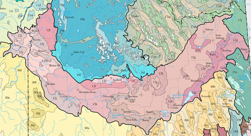
The pink shaded region is what I call Snake River Plain of Idaho
Source of graphic #1: https://en.wikipedia.org/wiki/Snake_River_Plain_(ecoregion)
Places to find some bright, sunny skies and will also be a little warmer than what you’ll find down in the valley
- Head to higher elevations. In most instances, you’ll need to get above 4,970 feet above mean sea level.
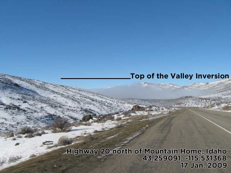
- Near Sage Hen Flats on Highway 20 north of Mountain Home, Idaho at 43.259091, -115.531368
- Bogus Basin Road at 43.732019, -116.147187. Map linked at https://goo.gl/maps/pGey5WWvKjNndBAUA
- Owyhee Front Area: I don’t know exactly where the top of the inversion is usually located on the south side of the Snake River Plains and the Owyhee Front. My best guess would be 42.737685, -116.319747 on Mud Flat Road. Map linked at https://goo.gl/maps/UYsph2tjApLRaBDS7

Inversion Mechanics
A wintertime inversion sets up in the Snake River Plains when a ridge of high pressure forms over the Pacific Northwest. The high pressure initially results in clear or partly cloudy skies in our area. During the early onset of the high pressure, a pool of cold air develops in the plains.
Under mostly clear skies and light winds, the low-level atmosphere starts to stagnate in the Snake River Plains. At night, the low-level cold, heavy and dense pool intensifies and cold air in the mountains drains down into the lower elevation and intensifies the low-level cold pool even more.
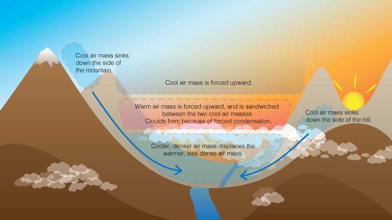
Above that cold pool of air, the upper-level high pressure ridge keeps the skies sunny or near cloud-free and the atmosphere warmer and windier. And that is an inversion with cold low-levels below 5,000 feet and warm air above 5,000. As the low levels of the atmosphere stagnate, clouds, fog, and pollution are trapped down there and things turn gray, cold and foggy/cloudy for all of us living in the Snake River Plains.
Additional Information
After an email exchange with Boisean “Robby Milo” who authors the website at https://rmilo.com/ , I came to the conclusion that the inversion in the Boise area has a similar vertical depth as in the Mountain Home/Glenns Ferry area. And that would be sound meteorological reasoning.
This story was originally published on 4 Jan. 2020.
Thanks,
~ signed ~
Tim Bondy
Freelance Writer & Citizen Journalist