
The Hike on NFS Trail 164A
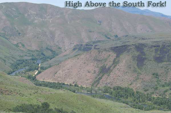
I parked just off NFS Road 164, more commonly known as the Dixie Cut-off Road, at coordinates 43.316615, -115.496536. From there, the hike is rather hilly as NFS 164A heads northward towards the bluffs above the Boise River. Once you hit the bluffs, and I use the term “bluff” loosely, the views along and into the Canyon are spectacular but the trail flattens out.
 |
| From Hike Above South Fork of the Boise River |
The big surprise during this hike was the “water”. Who thought there would be a large source of running water about 1,000 feet above the South Fork of the Boise River! The water comes in the form of an irrigation ditch that eventually dumps into the East Fork of Long Tom Creek. And this trail follows the irrigation ditch for about 1 mile all the while looking over the South Fork.
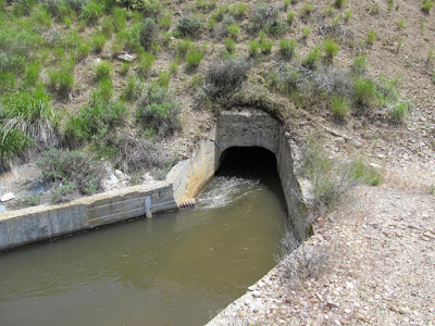 |
| From Hike Above South Fork of the Boise River |
At the ~ 1.5 mile point, NFSR 164A heads steeply up the hillside. At the top of this hillside you have 2 choices. Head south down to the Dixie Cut-off Road or head north along a ridgeline above the river. I took the ridgeline but stopped well short of where I wanted to go. Let’s just say the terrain is rather steep getting up to the ridgeline at coordinates 43.325616, -115.482263. This point was my turn around and head back to the car point.
The Animals of 164A
Snakes, birds, ducks, geese, and an pronghorn. All animals were harassed by my dog except the antelope who remained far enough away to be detected by Addie. But the ducks and geese really got the dog excited and she spend a lot of the time hunting them down in full speed sprints.
GPS Track on Google Map
View Larger Map
Blue line is the exact track I took.
Hike on NFS Trail 164A Stats and Information
- Road miles from Mountain Home to Parking Spot: 25.6 miles
- Miles Hiked: 3.55 miles but could be extended to over 5 miles
- Elevation Gain/Loss: 755 feet
- Land Ownership: The best information I have is this entire hike was done on National Forest Service lands.
- 1:24,000 USGS Topo Map: Anderson Ranch Dam, Idaho quad
- Link to all uploaded photos from this trip: https://picasaweb.google.com/112532322025941965882/HikeAboveSouthForkOfTheBoiseRiver?authuser=0&feat=directlink
Leave A Comment
If you liked this article let me know. You can also use the Facebook, Twitter or Google + buttons to show your support for my website.
Thanks,
