
The Hike Green Creek Trail
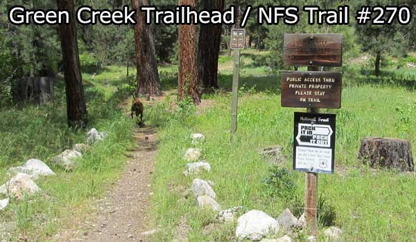
The Green Creek Trailhead also known as National Forest Service Trail #270 is located inside a rather large vacation home subdivision near the Johnson Hot Springs. And as such one would assume there would be a designated parking area but there isn’t. I could also assume there would be signs leading you to the trailhead but there isn’t. Signs and parking would likely ease any tension between landowners and hiker but it’s no skin off my nose either way.
Parking near the trailhead at 43.542973, -115.287412 you start the hike going through private property. But it’s not long before you are fully on NFS lands and heading uphill. You could possibly be sharing the trail with motorcycles, mountain bikes and horses as these folks are allowed. On this day, I didn’t see a single soul on the trail but there were motorcycle tracks.
 |
| From Mile High on Green Creek Trail |
Click for a larger photo.
For the most part, Green Creek remains relatively close to the trail and the sounds of the “babbling brook” were a constant companion and watering hole for my dog. On the section I hiked there were 2 stream crossing where your feet will get wet. And there were some sections were the stream was the trail but these sections were rather shallow and easy to navigate/stay dry.
My goal on this hike was to get high enough to enjoy sweeping views of the valley below. But the combination of a rather steep trail gradient and a section where the trail become a stream ended my hike. My secondary goal was to make it to the “mile high” or 5,280 foot point on the trail. I had to do a little off-trail hike to make it that high but I made it. And just to be honest, I was pretty darn tired and ready to turn around where I did.
 |
| From Mile High on Green Creek Trail |
Click for larger photo
Overall, I have done better hikes in this area. My only complaint was the lack of sweeping views. Yeah, I know…whine, cry and complain, when I don’t get spectacularly long vistas when hiking in Idaho. But the solitude, short range views and ruggedness made for a good hike. A hike I’ll do again just to challenge myself to make it to that saddle.
“Tracks On” National Forest Service Trail #270
View Larger Map
Interactive Map: The blue line is the track from my GPS unit and you can move the map.
Stats of Bondy’s Hike on Green Creek Trail
- Hike Mileage: 4.84 miles
- Elevation Gain/Loss: 1,412 feet
- Average Slope of Hike: 9.6%
- Water for Heat Intolerant Canine: Suspect creek runs most of the summer-fall season
- Road Miles Mountain Home to Trailhead: 56 miles
- Land Ownership: Mainly National Forest Service, Mountain Home Ranger District of Boise National Forest
- 1:24,000 USGS Topo Map: Featherville, Idaho quad
- Link to all uploaded photos from this trip: https://picasaweb.google.com/112532322025941965882/MileHighOnGreenCreekTrail?authuser=0&feat=directlink
Consider This
Spread the word…if you liked this article share it with someone you think might enjoy it also. Use the Twitter, Facebook and/or Google + buttons below if it would make it easier. Got questions or something burning a hole in your brain? Then leave a comment. So, have you ever hiked on the Green Creek Trail? Nope? Then get moving and do it.
Thanks,
