(Updated on May 24, 2019 / Author: Tim Bondy) Horsehead Spring in the Owyhee Mountains is located just off Mud Flat Road, 20 miles south of Grand View, Idaho. This November 6, 2010 hike generally followed a mostly dry creek bed (I’ll call it Horsehead Creek) that gradually became more and more remote and scenic. It doesn’t take much effort to find some solitude and pretty views in this area.
Rock Hounding was a Bust
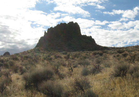
The route I took on this 4-mile round trip hike was rather barren of any rocks worth collecting. About the only thing I found interesting was some lava columns comprised of what I think was vesicular basalt. And these types of columns are rather common in this area of the Owyhee’s. In short, I’d say you can cross this area off your rockhounding “wondering/wandering” list. I’ve also hiked other peaks in this area and found nothing interesting, but your mileage may vary.
The Horsehead Spring Hike
The day started off with a few light rain showers but eventually, the skies cleared and it turned out to be a magnificent November Idaho fall day. As with every Owyhee hike I’ve taken, I encountered no one else out there.
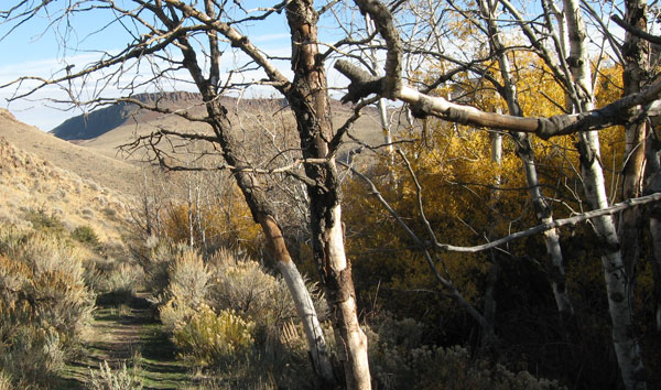
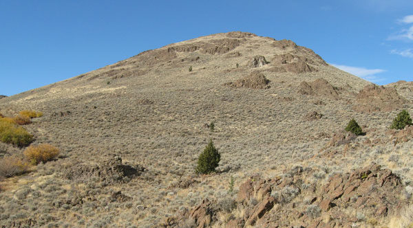
The Horsehead Creek draw was a nice hike as I gained almost 2000 vertical feet up to my stopping point just short of the true Horsehead Spring. There were scattered clumps of trees in the draw displaying their waning fall colors. The bright yellowy-orange foliage certainly contrasted nicely against usual tan-brown-silver colors of the landscape in this area.
As there are virtually no hiking trails in the Owyhees, this hike was mostly cross country. But this is ranching country also. Most every valley or draw you chose to hike there will be cow trails. In places, the cow trails along Horsehead Creek were better maintained than some National Forest Service trails. This makes for easier going through the brambles of sagebrush and thorny bushes close to the dry streambed.
My Hike Location by Coordinates
- Where I parked: 42.749193, -116.309572
- Hiking up to the higher ground: 42.755335, -116.314772
- Horsehead Creek starting point: 42.756690, -116.322241
- Where I turned around: 42.763559, -116.334075
- Map link of the general area: http://maps.google.com/maps/ms?ie=UTF8&hl=en&msa=0&msid=111249431318674283266.0004947c607cced158d2c&ll=42.756592,-116.322212&spn=0.048841,0.132093&t=p&z=14
Note: Copy/Paste the above lat/long into Google Earth or Google Maps will give you the exact location.
Animals, Hunters, Cows, Ranching and the Environment
Hunters are always a concern when I hike Game Management Unit 40 in the Owyhee’s during Oct/Nov. Thankfully I saw no hunters but that doesn’t mean they didn’t see me. I saw many places were big game bedded down recently. Obviously, the deer, elk and/or antelope saw and smelled me and headed towards a safer place before I got near them. It appears as if the upper portions of this hike would be prime hunting grounds for the adventurous hunter. But there aren’t any roads or ATV trails close so filling a tag means a rough trip out with 100-150 pounds of dead weight.
The numerous cow trails along Horsehead Creek is a blessing and a curse all in one. The easier hiking is offset by the sheer amount of cow poop in places. While all the cow patties I stepped over, in and around were old, it certainly still attracted clouds of flies. Once I got into the rougher sections of this BLM and State land, the flies magically disappeared.
Owyhee Wildlife?
The only animals I saw during my hike were 7 or so rabbits and a lot of the normal birds. This is coyote territory and I saw plenty of evidence these animals call Horsehead Creek their home. While this creekbed is dry, I found 4 places with standing water in the low spots. I’d like to head up to this area again during the morning or early evening for some wildlife viewing.
I’ve done a fair amount of hiking and rock hounding in this general area. I’ve been off the beaten trail to places I’d never expected many or any people have ever been to. But these are the places I’ve found trash and other signs of stupid people. On this Horsehead Creek hike, the land was clean except the ever-present ranching stuff.
Land and Fences in the Horsehead Spring Area
All the land I traveled on during this hike was either “managed” by the BLM or the State of Idaho. One would think fences wouldn’t be a problem out in this isolated area but they are. Grazing allotments seem to blanket the Owyhees and I suspect each allotment is fenced off??? Even where there are gates, they are difficult to figure out how to open them. This leaves the hiker, hunter or rockhound only one option and that is to find a place to climb over or under these barriers.
Advice to Hikers and Rockhounds
Owyhee County is close to Mountain Home and a perfect place to get out to experience our vast public lands. Hiking is wide open down there and with a little research, you can easily avoid private lands. For rockhounding, the wide open public land is an invitation to get out to find some cool rock, gems, and geology. All this land is as close as 45 minutes from Mountain Home. Using Mud Flat Road means you get to avoid bad roads completely.
More pictures from this rockhounding and hiking trip:
https://photos.app.goo.gl/TLvR2Rby6mntd2Cm7
This article was originally published on this website on November 7, 2010. The story was edited, modified and republished on May 24, 2019.
Thanks,
~ signed ~
Tim Bondy
Freelance Writer & Citizen Journalist
“Great effort springs naturally from great attitude.” ~ Pat Riley