
Fishing the Middle Fork of the Boise River is always a fun adventure. This is a beautiful river that takes some dedication to get to from Mountain Home, Idaho. I suspect most people get there via I-84 and up Highway 21 traveling about 130 miles to the Phifer Creek Bridge. But this is the long boring way.
For those who have a vehicle in good condition or an ATV they can get there by traveling through Featherville and Rocky Bar, Idaho. This is my normal route which is about 85 miles each way. I suspect the travel time is pretty close either route you chose to get to the Middle Fork. I’ve fished this river a number of times but always from the Phifer Creek Bridge and upstream to or past Atlanta, Idaho
Mountain Home to Rocky Bar and on to The Middle Fork
I left Mountain Home around 7:30am on Saturday August 21st 2010. Plans was to leave at 6:00am but, well…you know how things like this happen. It was a nice drive with pronghorns lining the road above Anderson Dam and mule deer all along the road down to the reservoir. “The Lake” was quite crowded on this morning with at least 15 boats motoring around even before 8:30. The shore was crowded with campers…more than I have ever seen at Anderson Dam. By the time I past Featherville and was arrived at my parking spot near Rocky Bar, the temperature dropped from 57F at home to 44F. I unloaded the Arctic Cat ATV and headed up into the mountains. At the Trinity Ridge Road / Phifer Creek Road intersection I turned right and headed down towards the Middle Fork. As usual, the sweeping scenery of the Boise National Forest and Steel Mountain area made the trip enjoyable. I did not encounter another human this entire route. I did encounter a three unattended horses near the Trinity Ridge intersection just grazing along the road. What’s that all about?

The Middle Fork Road to Atlanta
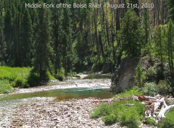
The Middle Fork Road closely follows the Middle Fork of the Boise River to a few miles past Atlanta (no duh, Tim). It’s easy to keep your sights on the river itself, but some places in this canyon the geology, ruggedness and beauty are unmatched anywhere in Idaho. There are plenty of places to pull off the road to explore the river. This is mining county so you will see huge piles of dredge tailings in many places that hide view of the river. In the numerous places to get a view of the Middle Fork, the color of the pools can be quite stunning in their almost emerald green hue. Once you get close to Atlanta, the river changes somewhat and is off to north side of the road and harder to see.
As compared to the roads I took getting down to the Middle Fork of the Boise, the Middle Fork Road could be considered a busy road. Granted this was a weekend day in August but the road was quite busy as compared to other trips I’ve made here. I was pretty dusty and grimy after this drive and most of it was from the Middle Fork Road.
As I said earlier, this is mining country and I guess the lure of “$1,200 an ounce gold” has more and more people trying to strike it rich. There are more small time dredge operations in the river than the last few years (in my opinion).
The Middle Fork of the Boise River Fishing Report for Saturday August 21, 2010
For those of you that have made it down this far you get my less than expert fishing report. The good news is the fishing was very good with about 12 trout caught in various places in the Middle Fork. The bad new is the fish were all pretty small. I did catch two rainbows in the 10 inch plus range and were more fun to reel in on my newly spooled 4 pound test line. The fishing pressure on this river is likely relatively high but I didn’t see another fisherman along the road today…and it was a Saturday.
Fishing Hole #1 is found at 43.817304, -115.35248 and is close to the Phifer Creek Bridge. The water is clear and the pool is relatively deep. I caught one small rainbow trout in this pool but lost a few as I reeled the fish towards shore. These were also small trout and thanks to barbless hooks, I didn’t have to stress them out pulling hook as they spit the lure.
Fishing Hole #2 is found at 43.816568, -115.346981. This place takes a little work to get to as it is located on the other side of a long dredge tailing rock pile. These rock piles aren’t the easiest things to walk on. Climbing up and down these steep rocks is an adventures all to itself. There were times it was 1 step up followed by sliding back 2-3 steps with large rocks rolling into my legs. I caught one small trout and my biggest rainbow of the day in this pool.
Fishing Hole #3 is at 43.829363, -115.323257 and is a long elongated pool. Two small trout were pulled out of this hole and released just as fast. There appeared to be a lot of trout in this area as I saw lots of fish rising to the surface in search of whatever hatch was ongoing.
Fishing Hole #4 coordinates are 43.829087, -115.312612 and didn’t appear to be a great place at first. I caught 3 trout here and the 2nd biggest fish of the day was hauled out of this pool. This fishing hole is hidden from the road behind the tailing but not difficult to get to. From this pool I could see a promising looking fishing spot downstream. So when the fish stopped biting I sloshed down the river, slipping and sliding the 150 yards to fishing hole 5.

Fishing Hole #5 is located at approximately 43.829167, -115.314062. This awesome looking pool is a large circular swirling fishing hole that is quite scenic. The water is clear and has that tropical green hue color. This pool is well hidden from the road as a steep dredge tailing pile extends almost into the pool. I call this pool the “Second Trip Pool”. In any case, I caught 2 trout in this pool using an orange spinner and a yellow spinner. I also got the opportunity to cool off before I left “the first time”. It was quite hot in the Middle Fork of the Boise River canyon on this day so I waded in up to my neck but got out quickly. Once I air dried a little I climbed the 20 foot rock pile behind me and hopped on my ATV. It was then I noticed I forgot my little tackle box at the fishing home. I got to climb back up and down those rocky piles again to gather my fishing tackle. Thus, I call it the “Second Trip Pool”.
I stopped at a few other fishing holes as I made my way towards Atlanta and caught a few more fish. There are plenty of places to get your line wet and I’m sure there are some big fish in the Middle Fork of the Boise. I guess the important part is to have fun, enjoy nature and don’t get caught up on size.

Snowbank on James Creek Road? In Late August?
Coordinates: 43.795189, -115.183603
I decided to head back to the Rocky Bar and the truck via James Creek Road. Not long after heading up this rough and rocky road I came across a pretty large snowbank on the side of the road. Large for August in Idaho in the low elevations that is. My thoughts are a large avalanche swept down the steep mountainside during the Spring and there is still some evidence of this event just sitting there for me to wonder about. In any case, James Creek Road and surrounding hillsides are still green and covered with wildflowers. In all the times I have been on this road late in the summer, I never remember it being so wet and green. Mother Nature sure works in mysterious ways throughout our Idaho mountains.
See More Picture of this Trip: http://picasaweb.google.com/tim.bondy/FishTheMiddleForkOfTheBoiseRiver?feat=directlink
Thanks for visiting and commenting on this Idaho Fishing report.
Tim Bondy
The Bondyweb.Com author