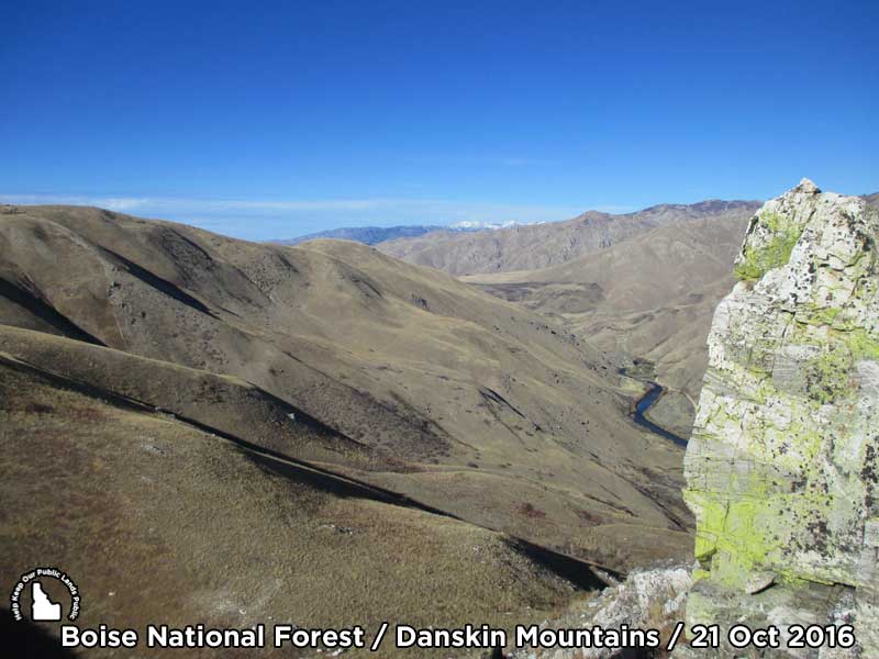
(Updated on April 11, 2019 / Author: Tim Bondy) This steep climb to a ridgeline above the South Fork of the Boise River is a good introduction to cross country hiking in Elmore County, Idaho. Like a majority of the hikes in the Danskin Mountains, it was virtually tree-free and trail-free. The scenery is the reason for hiking this ridge.
Featured image at 43.32617, -115.54455 and linked at https://photos.app.goo.gl/4vZzMWjYMwr2SwJc8
Many years ago, while driving on a gravel road called National Forest Service Road 131 toward the South Fork of the Boise River, I told myself “someday I will climb that ridge” located near 43.3267112, -115.5562606. The treeless ridge extends east-west for about five miles just south of the Boise River.
On Friday, October 21, 2016, I finally found the gumption to attempt the hike. I expected it would be a very steep climb up the ridge but also believed the views would be outstanding. My expectations and beliefs were exceeded in both categories.
Once Parked, Identify You Destination and Set Off
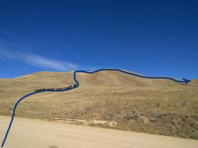
At the trailhead, the big treeless ridgeline to the northeast is your destination. My research indicates there is a small section of private property bordering the northern side of the road, extending a short distance up the hillside. However, I saw no signs, fences or any indications private property exists in the immediate area. If you are like me, you’ll do the research to avoid trespassing. I did and you should too.
“There is private property located in the vicinity of this hike. Do the research or you can be fined.“
There are no trails, markers or anything to guide you to the top of the ridgeline. Pick a route that looks appealing to you and put one boot in front of the other until the landscape levels out. Please take the time to stop and soak in the views from all directions on the way up. You’ll enjoy the scenery while catching your breath.
On The Ridgeline
From FSR #131 to the ridgeline is only a three-fifths of a mile scramble but the devil is in the details, with an almost 900-foot vertical climb in that short distance. Once you conquer that little climb, you can walk the ridgeline to the east for over three miles. Just remember you have to hike back also.
The views from the ridge are spectacular, ranging from the Trinity Mountains to the north and the Soldiers Mountains to the northeast. Bennett Mountain, our local mega-mountain dominates the view to the southeast.
Fifty plus miles to the south and southwest, the Owyhee’s Bald and Rough Mountains are visible. And if you get high enough on one peak, you can make out the Silver City Mountains.
The 1,500 foot view down into the South Fork of the Boise River canyon is quite unusual. A view not many people have seen makes this short but strenuous hike well worth the time and effort.
The landscape was about as a “trash-free and cow patty-free” of a hike I have been on in this area. I brought home an old soda can and a piece of aluminum foil as the only souvenirs (trash) of this hike. On the other hand, the scramble up the ridge you will find a lot more cow patties and a few more pieces of trash. Such is human nature.
The hike stats:
- Date of Hike: 21 Oct 2016
- Trailhead: at the intersection of NFS-131 and an unnamed ranch road at 43.32341 -115.55944. Making sure to not block the roadway.
- Hiking Mileage: 2.63 miles
- Elevation Gain/Loss: 1,060 foot elevation gain/loss
- Elevation: It ranged between 4,633′ and 5,435′
- Max / Avg. Slope: 41.4% with an average slope of 13.8%
- Photo Album: https://goo.gl/photos/RKZ7rx2PzdVsMf2h8
- Total Time Door-to-Door: 4 hours and 10 minutes.
This post was originally published in Oct 2016 on the http://www.bondyblogs.com website. It has been updated and republished on this website on April 8, 2019.
This is my life just off Interstate 84 in Elmore County, Idaho.
T.B.
Tim Bondy
Freelance Writer
Ending Pun: A sports coat worn on a hike is a trailblazer.


