(March 27, 2019 / Author: Tim Bondy) This cross country hike in southwestern Idaho’s Danskin Mountains that started near a creekbed I call Bowns Creek East wasn’t one of my favorite hikes. There is potential for some very cool hiking terrain in the area and that is what will draw me back to this area in the future. The main canyon I hiked isn’t one of the features.
Featured Image Information: 43.3878021, -115.827919 / https://photos.app.goo.gl/iwZReptrM2y4J7T1A
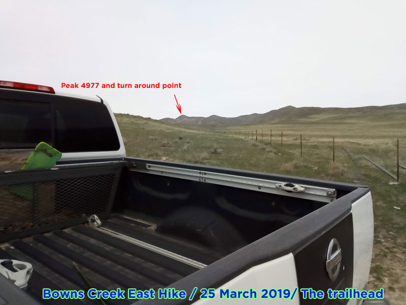
The Bowns Creek East Hike
This is the second time I have hiked in this same area. The first time was last year on March 23, 2018. I changed the route significantly on this adventure. Previously I hiked just the ridges. On this March 25, 2019, hike, I followed the creekbed northward and then headed totally cross country into the high country and the ridges after about 1.5 miles.
The self-named “Bowns Creek East” canyon has been extensively grazed by a lot of cattle. And all this grazing was done after the pretty disastrous 2013 Pony Complex. In short, there were a massive amount of cow patties everywhere I tread. The natural vegetation is rather sparse even considering the growing season probably just started a week or so ago in this area.
The High County and Wind
Once I headed out of the canyon and riparian area and started up toward the high country, the number of cow patties decreased but they were ever-present, nonetheless. So, it was a relief to get into a slightly healthier environment even if it was quite steep in some of the pitches.
Once I got up on the high ridges, there was an ATV doubletrack that I took a little higher towards the north and Peak 4977. I never made it to that peak because of the winds. Regrets? Yes, as I was just 400 feet from summiting out on Peak 4977.
Let’s talk about the wind on the ridgetops. It was ferocious. As I was plodding up towards Peak 4977, the wind made it hard to even walk. My guess, as an ex-weather forecaster and observer, was that the winds were blowing a steady 50kt, gusting to 75kt. I was tired, sweating and freezing all while, being assaulted by hurricane force winds.
“It was so windy I saw cow patties tumbling up and over the ridgeline on a number of occasions. Normally, there would be tumbleweeds tumbling but this day was unusual.”
The walk back to the trailhead was uneventful with the exception of walking up on a rather large herd of mule deer. Considering this hike was primarily an antler shed hunting trip, seeing that many deer I considered it a good sign. And yet, I came home empty-handed.
The Bowns Creek East Hike Stats
- Adventure Date: 25 Mar 2019
- Consider Doing it Again?: Yes
- Trailhead: 43.387795, -115.827975
- Trailhead Temperature: 52°F
- Turn-Around Point or Furthest Out Point: 43.412535, -115.802335
- 7.5 Topo Maps: “The Roost”
- Trail/Road #: None, 100% cross country hike
- Land Ownership: 95% public BLM lands with a small section of Idaho State lands. FYI: Private property hems in the first 1/2 mile from a Mayfield/Foothills Road trailhead
- Mileage: 5.13 miles
- +Vertical Feet: 1,433 feet
- Avg Slope from Google Earth Vertical Profile of the GPX File: 9.1%
- Health of Local Environment – [
Excellent / Good / Fair / Bad /Horrible]: Horrible, for abundant cow patties but very little trash. Seriously, there was a lot of cow shit on this entire hike. - Wildlife: A large herd of mule deer was encountered. There were a huge amount of deer/elk droppings along most of the route.
- Google Photo Album Link: https://photos.app.goo.gl/SXa5pNYbFeybdWCm6
- KML/KMZ File: DANSKINS – Hike – Bowns Creek East Hike.kmz (local file only)
- GPX File Name: 20190325-133333.gpx (local file only)
- Random Google Map Link on the Route: https://goo.gl/maps/J7kwFLscVo62
- Driving Time to Trailhead: 35 minutes
Topo Map and GPX Overlay Image
Bowns Creek East & a Singletrack for Mountain Biking
A singletrack has developed along and on both sides of the creekbed I’m calling “Bowns Creek East.” I guess cattle and wildlife combined to create them. And, while dropping down into the creekbed would be a little difficult, there is an adventure waiting for someone to mountain bike this 3.2 mile out and back trail. Will you be the first?
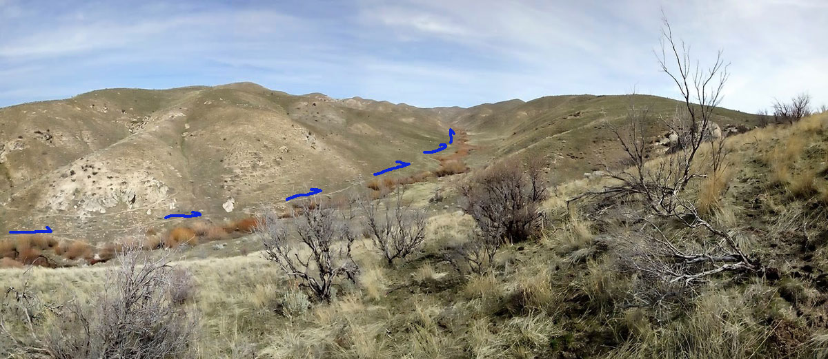
Also, the ridgeline on the left side of the photo has an ATV doubletrack you could ride/push a mountain bike up. The ride down would be fun. The ride /push up? That is something I wouldn’t attempt but a younger, more fit version of myself would be out there this month if he existed. 😎
NOTE: I do not know the legalities of riding a mountain bike on the above mentioned single/doubletracks.
Originally published on March 27, 2019
Thanks,
~ signed ~
Tim Bondy
Freelance Writer & Citizen Journalist
“Mountains have a way of dealing with overconfidence.” ~ Nemann Buhl