(March 19, 2019 / Author: Tim Bondy) This Danskin Mountains hike starts at the lower portion of Immigrant Road and eventually heads up to the ridgeline just south of Long Tom Creek in southwestern Idaho. The trailhead is 14 miles north of the little town of Mountain Home. This was my first early season hike in 2019 and it was designed as an antler shed hunting hike. Mule deer were plentiful but antlers were not.
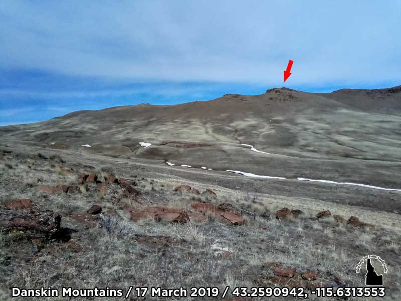
Featured Image Link: 43.2590942, -115.6313553 / https://photos.app.goo.gl/XN7WfUu7wnc8Nvpt6
A publicly accessible ridgeline exists south of Long Tom Creek (below the dam) and has been one of my go-to hiking locations in the last few years. The ridgeline is close to Mountain Home, Idaho and provides steep and challenging terrain for me. For as many times as I have hiked in this area, I’ve encountered very few people out there … Mainly hunters.
This specific location is heavily grazed so expect a lot of cow patties and an unhealthy sagebrush steppe environment. The views and opportunity to watch sizable numbers of deer and some elk on this hike more than made up for the unpleasant ranching landscape.
Antler Shed Hunting Trip Report South of Long Tom Creek
- Adventure Date: 17 Mar 2019
- Consider Doing it Again?: Yes
- Trailhead: 43.250850, -115.635288
- Trailhead Temperature: 51°F
- Turn-Around Point or Furthest Out Point: 43.266304, -115.629821
- 7.5 Topo Maps: “Syrup Creek and Long Tom Reservoir”
- Trail/Road #: None, 100% cross country hike
- Land Ownership: The first part of the hike is on Idaho State lands and the rest is on BLM lands.
- Mileage: 3.3 miles
- +Vertical Feet: 1,132 feet
- Avg Slope from Google Earth Vertical Profile of the GPX File: 11.8%
- Health of Local Environment – Excellent / Good / Fair / Bad / Horrible: Abundant cow patties, cheatgrass, and trash
- Wildlife: About 40 mule deer and a few elk
- Google Photo Album Link: https://photos.app.goo.gl/XN7WfUu7wnc8Nvpt6
- KML/KMZ File: Immigrant-Long Tom Hike.kmz (local file only)
- GPX File Name: 20190317-133643.gpx (local file only)
- Google Map Link on the Route: https://goo.gl/maps/GHv3fMQ19b62
- Driving Time to Trailhead: 30 minutes
GPS Track On Topo Map
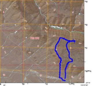
I am looking for a better way to present a topo map with my gpx. track embedded in the graphics. If you know of a simple and easy method, please contact me.
“From the ridgeline, the entire Owyhee Front is visible. They extend from the Jarbidge Mountains in Nevada to the Silver City Mountains south of Boise.”
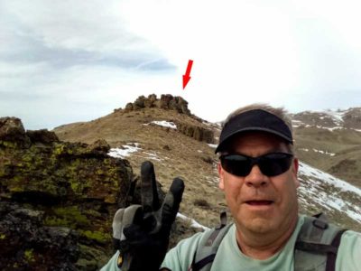
My “turn-around spot”
Originally published on 19 Mar 2019
Thanks,
~ signed ~
Tim Bondy
Freelance Writer & Citizen Journalist
“Adventures belong to those who create them .” ~ Unknown