
(March 5, 2019 / Author: Tim Bondy) This mountain bike ride in Idaho’s Big Hill and Wickahoney area of Owyhee County and just east of the Big Jacks Creek Wilderness was surprisingly enjoyable. It’s a rather remote area even though it’s not too far from the town of Bruneau, Idaho. Once I climbed into the Big Hills the views of our ” local canyon area” and the buttes near Big Jacks Creek were outstanding.
Link to featured image: https://photos.app.goo.gl/upAzqph1BLkCaic88
Introduction Big Hill and Wickahoney Area MTB Ride near the Big Jacks Creek Wilderness
I didn’t expect much out of this ride in the Owyhee Desert but it turned out to be better than I could have hoped. The first 2.5 miles of this 17 mile out and back ride was rather uninspiring as it heads west toward the Big Jacks Creek Canyon. Once the doubletrack trail starts heading south, however, the scenery and trail get a lot more interesting.
As the trail heads into what I call the Big Hill area of this part of Owyhee County, the ride gets downright strenuous, rocky and rutted in parts. In other words, it’s not just a ride on a dusty doubletrack.
Once you get up on what I call “The Escarpment,” the views over the canyonlands are quite spectacular. It also extremely isolated and unless you’re out there during hunting season, I wouldn’t expect to encounter another human being. However, this is ranching country so expect lots of cow patties and the possibility of meeting up with a cowboy if your timing is just right.
FYI: I saw quite a number of elk and deer while on this ride but not a single human nor vehicle.
Pro’s: The scenery and isolation as well as the surprising technical challenges of the doubletrack make this a candidate to ride again.
Con’s: Cow patties and tons of them. You cannot avoid them. The isolation makes getting hurt while riding in this area a serious issue.
Idaho’s Big Hill and Wickahoney Area MTB Ride near the Big Jacks Creek Wilderness Trip Report Basic/Stats
- Adventure Date: October 23, 2018
- Consider Doing it Again?: Yes
- Trailhead: 42.670451, -115.905250
- Turn-Around Point or Furthest Out Point: 42.604675, -115.975933
- 7.5 Topo Maps: “Hole in Rock” & “Wickahoney Crossing” maps
- Trail/Road #: The trails are included on the Idaho Parks and recreation map as a BLM Automobile road
- Land Ownership: All BLM lands but a little State land and designated Wilderness is also located nearby
- Mileage: 16.72 miles
- +Vertical Feet: 1,933 feet
- Avg Slope from Google Earth Vertical Profile of the GPX File: 4.4%
- Google Photo Album Link: https://photos.app.goo.gl/cakveR5x2s7c7AQf8
- Google Earth KMZ: OWYHEES – Bike – Big Hills and Wickahoney Area Rides.kmz (local file only)
- GPX File Name: 20181023-150815.gpx (local file only)
- Driving Time to Trailhead: 45 minutes to turn-off from Highway 51
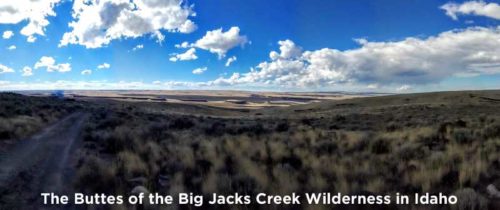
Panorama at the Turnaround Point
Originally posted elsewhere (https://timbondy.blogspot.com/) Last updated on December 28, 2018
Thanks,
~ signed ~
Tim Bondy
Freelance Writer & Citizen Journalist
“Not to know is bad; not to wish to know is worse.” ~~ African Proverb