Last updated on January 23, 2019, to fix broken links.
(Hiked on 2 Nov. 2013) The idea of hiking along the north bank of Long Tom Creek where it dumps into the Reservoir has fascinated me for a few years now. And with a strong cold front moving through this area, I decided I needed to stay close to Mountain Home, not stray too far off the beaten path but explore a new place. The area north of Long Tom Reservoir was the perfect location for a hike.
Stay High and Dry
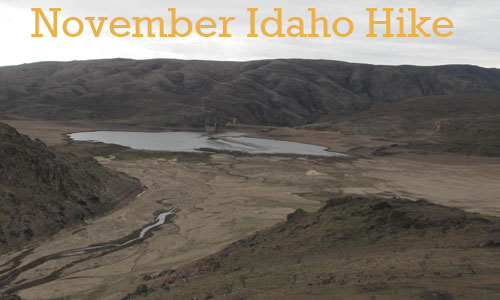
Being a very dry year, Long Tom Creek is probably at historic lows and the size of the reservoir probably wasn’t anywhere near normal either. I figured hiking the ridge-line north of the creek would give me a good vantage point to check out the surrounding scenery. It did.
The cold front was obviously moving in rapidly as dark, gray and steadily lowering clouds moved in from the west. I knew it wouldn’t be long before it started to rain. The only question was how hard and how long would it rain. The rain started just as I reached the ridge-line above Willowdale Creek that dumps into the northern side of the reservoir. This would be my turn back point.
The Apocalypse Landscape
Plain and simple, the area around Long Tom Reservoir got burned pretty badly during the August 2013 Elk Complex Wildfire. And my path took me straight through the burn scar and this wasn’t something I had thought about until I hopped across Long Tom Creek at the beginning of this exploration hike.
I knew this area wasn’t a rockhounding spot so scenery, the exercise, and exploration were the only reasons to be out here. Unfortunately for me and the land, there were places on this hike I felt a Hollywood crew could film a realistic type apocalyptic, end of the world as we know movie without any problems. The fire burned off a vast majority of the sagebrush leaving near bare ground. It was just plain ugly and empty in these places.
Low, Sandy, Easy and Wet
When the rain started, I had a few choices. I could head north, get on the dirt road and head back. I could head back along the ridge-line I just walked. Or I could take the easy way back to the car along the now dry Long Tom Creek-bed.
I headed down to the creek bed and headed due east. This was some easy hiking on the sandy shores of Long Tom Reservoir and Long Tom Creek. The rain continued for the entire hike back. Fortunately for me, the rain was relatively light.
It was kind of cool seeing the river bottom I fished back in April 2012. You can read the story at … [sorry, the link is broken]
The Adventure Scorecard – 5 Stars or Worse
- Remoteness: 3 Stars – I doubt many people venture out here.
- Beauty: 2 Stars
- Cleanliness of Our Lands: 1 Star for the copious amounts of burned cow patties and scorched landscape.
- Rock Hounding: Not Calculated
- Wildlife: 1 Star – Only saw a few birds and very little sign of any big game in this area. Weird
- Overall Score: 2 Stars
Links
View a map of the area at http://www.acme.com/mapper/?ll=43.29782,-115.56879&z=14&t=T
View some more photos at https://picasaweb.google.com/112532322025941965882/20131102?authuser=0&feat=directlink
(may not be accessible to everyone at all times…sorry)
This is my Life Off Interstate 84 in Mountain Home, Idaho

