
On Sunday January 8th, 2012 I took a hike in a place I’ve been meaning to hit for the last few years. The lack of snow, cool temperatures and blue skies came together in a grand fashion for this “Castle Rocks Hike”. Located only about 30 miles northwest of Mountain Home off Highway 20 made for quick easy access to this scenic hike.
The Castle Rocks Hike
With my dog in tow, we parked at a borrow pit off NFS Road 152 or what is more commonly called Castle Rock Road. We headed east-northeast on this snow cover road for about 1 hour.
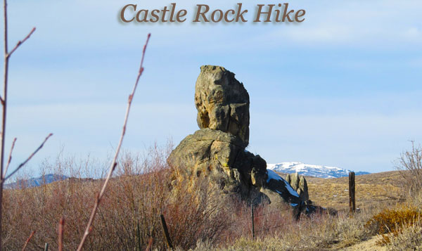
This is wide open country with an abundance of sagebrush and only scattered tree cover mainly along creek valleys. As the name of the road suggests, the many rock formations are the big draw in this area. It did not take long before we were walking past the first big boulder cluster. As we got further into the hike, rock formations became more frequent and infinitely more interesting.
 |
| From Castle Rock Hike Jan 2012 |
Castle Rock Road slowly gains in overall elevation the further east you hike. But in reality, the road meanders up and down the many shallow draws in this rolling terrain. The land along this hike is a mixture of US Forest Service land and private property although the roadbed is a public thoroughfare. The coolest rock formations on this hike appear to be on private property.
This isn’t a remote hike by any stretch of the imagination. Highway 20 is never more than 2 miles away and vehicle traffic/noise can be seen and heard at times. But don’t let this fact discourage you from getting out there and enjoying this cool area.

If I was younger and more adventurous, I would have been tempted to try some bouldering on these rock formations. In my younger days I did a fair amount of bouldering (without the crash pads) in Southern California. On this day I left the dangerous stuff to my dog Addie. She is a natural on boulders and fearless too.
The Hiking Stats
Total Hike Mileage: 3.18 miles
Elevation Gain/Loss: 520 feet
Average Slope: 5.8%
Driving Time from Mountain Home, Idaho: 27 miles or about 35 minutes
Drive Distance on Dirt Roads: 3/5 of a mile
Link to more pictures: https://picasaweb.google.com/tim.bondy/CastleRockHikeJan2012?authuser=0&feat=directlink
Hope you enjoyed the story of my Castle Rock Hike. Check back soon for a video from this area.
