
2011 was supposed to be my year of widespread Idaho exploration. That all changed when I got laid off from my job. At the beginning, I was a little depressed that money worries would prevent me from enjoying Idaho. I soon found out that exploring locations close to home and “doing it on the cheap” by driving less than 75 miles was just as enjoyable as traveling to far away places.
An Earlier Fork in the Road
Eleven days earlier I was exploring a trail close to Soldier Mountain Ski Area near Fairfield, Idaho. At that time I had a choice of 2 different trails to hike. On that day I chose the non-motorized trail along the North Fork of Soldier Creek. This was quite a wonderful place and I would now place it second on my list best places I visited in 2011. You can read about this trip at:
Insert link here: Early Fall Hike Near Fairfield Idaho

South Fork of Soldier Creek. The Best Hike of 2011.
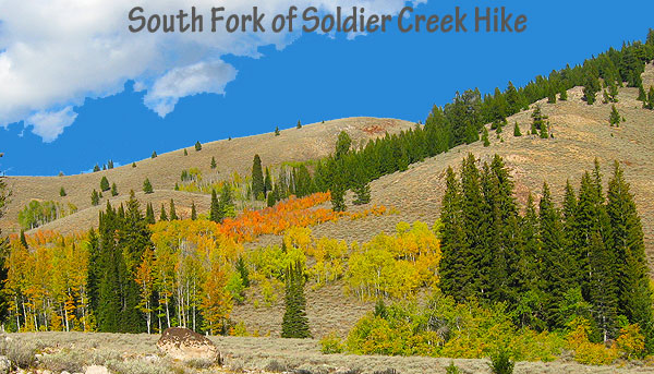
(October 14th, 2011) My destination was a ridgeline close to the 10,095 foot mountain called Smoky Dome in the Sawtooth National Forest. I knew I wouldn’t make it to the planned ridge but I did not want to limit my options as I always leave a detailed map package of my planned route with my wife in case something bad happens. And to honest, I did not think the South Fork of Soldier Creek hike could come close to besting the North Fork hike I took earlier in the month. But I was wrong.
The Hike
Parking at the trailhead (43.498521, -114.834811), I set off with my crazy dog Addie and headed west up National Forest Trail 087. The views in the low levels were nice and with the South Fork creek still flowing pretty good, the dog was free to cool off and drink as much water as she could handle.

For the fishermen out there, I was surprised at the amount of small trout living in the numerous pools. Almost every place we stopped to explore the creekbed, I saw trout. But for the rockhounds, there isn’t much to see out here. I suspect once you get up near Smoky Dome, there are better prospects.
The further west you head up NFS Trail 087 the better the scenery becomes. Due to the lateness of the season, the trees were changing with a lot of brilliant yellows the primary change color. In places I occasionally caught glimpses of the snow covered Smoky Dome area. This section of mountains is quite dramatic, beautiful and what keep me moving forward and upward.
 |
| From South Fork of Soldier Creek |
Just as the trail started heading up a steeper ridge, I decided to call it quits. I headed southwest off trail (43.507225, -114.889798) towards the source of the South Fork of Soldier Creek. We found a meadow and a nice big rounded boulder to eat lunch on with a fabulous Smoky Dome view. You’ll not find a better place to nosh on a stale old peanut butter sandwich in my opinion.
I took a lot of pictures and we headed back down:
https://picasaweb.google.com/tim.bondy/SouthForkOfSoldierCreek?authuser=0&feat=directlink
It was time to head on back but we decided to try out a side trail that paralleled NFS 087 in this area that I found on my GPS unit. It certainly was a different environment, with a much marshier look and feel. It felt more like hiking in the Washington Coastal Range for a short amount of time. A shallow South Fork of Soldier Creek crossing got us back out on the main trail and the 3 mile hike back to the car.
 |
| From South Fork of Soldier Creek |
What I Loved About the South Fork of Soldier Creek Hike
The scenery was probably the best I’ve seen on any hike this season. I wish I was in better shape and could “dayhike” up to the ridges around Smoky Dome. But what I saw was enough to classify this hike as the epic 2011 Bondyweb Hike of the year. As far as the things I did not like? Having to leave that meadow where we had lunch is the worst thing I can say.
Stats of the Hike:
- Total Hiking Mileage: 7.0 miles on this out and back hike
- Average Slope: 8.2%
- Elevation Gain/Loss: 1,667 feet
- Highest Point of Hike: 7,402 feet
- Stream Crossings: 1 on-trail and 3 or 4 off trail.
- Mileage from Mountain Home to Trailhead: 71.2 miles with 1.2 miles on gravel/dirt roads.
Comments
This is your time to make comments or ask any questions about the South Fork of Soldier Creek hike. Let’s hear what you have to say about this Best Hike of 2011.
Thanks for visiting my website,
