(Updated on May 4, 2019 / Author: Tim Bondy) Looking for a short but picturesque day hike? How about some gold panning along two lush and verdant creek valleys? Time is running out but if you plan now, you can still experience one of the best day hikes I have taken in Southern Idaho. I’m calling this hike the “Whiskey Jack Hike”, but its official name is FSR #172B.
Featured Image Info: 43.638533, -115.356897 / https://photos.app.goo.gl/E6YLbNUhdbfQ39ez7
Where is Whiskey Jack Creek
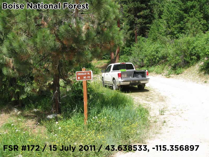
The trailhead for this hike is about 5.3 miles (as the crow flies) from Featherville and just off Trinity Mountain Road.
- I parked at 43.638533, -115.356897 next to the sign for Crosscut Trail #172.
- Walk up the often used FSR #172 through a switchback and then bear left or north at 43.639757, -115.356328 or at the sign for FSR #172B.
- After about 100 yards the trail forks either west or north. Take FSR #172B to the north and your journey begins.
Heading Down to Whiskey Jack Creek
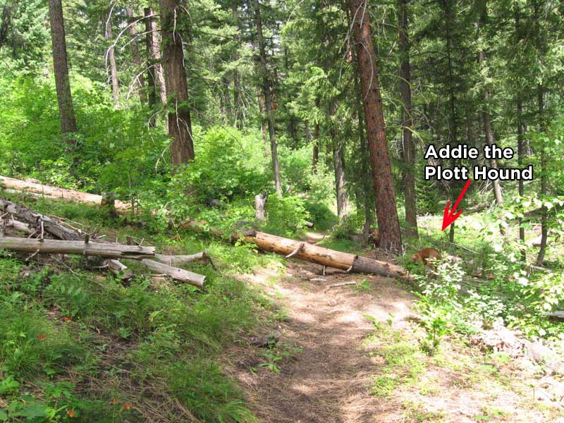
Once you head away from Trinity Mountain Road and get on to FSR #172B you are at a ridgeline above Whiskey Jack Creek. You head steadily downwards on a nice hiking trail that also allows motorcycles. This portion of the trail is quite shady, lush with ferns, brush and lots of downed tree in the intermittent creek valley. There was some water running in this stream but very little.
Crossing Whiskey Jack
Once you level out in the bottom of Whiskey Jack Creek valley, the hillsides are more open and bare. But along the creek, there is a veritable fortress of brush and bramble protecting the streambed. The trail will lead you to an opening to cross Whiskey Jack but don’t expect to stay dry.
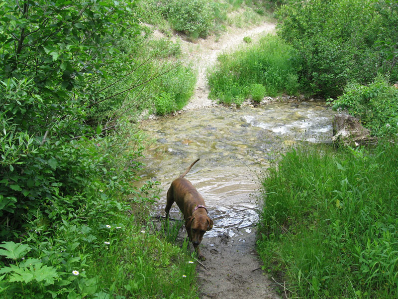
I had to walk through the stream which was easy but I certainly didn’t want to soak my boots at the ¼ way mark of the hike. On this mid-July 2011 hike, the stream was about 10-15 feet across and 12-18 inches deep in the middle.
Campo Creek to NFS Road 170L
The trail on the other side of the stream crossing heads downstream or east for a few hundred feet before heading north again. This is when the trail starts following Campo Creek. It’s a moderate climb for the rest of the hike.
The scenery just got better and better the higher I climbed. It remained lush and green along the creek and a mixture of lodgepole pines, Douglas Firs bordered the trail. I suspect this area was logged at one time in the distant past as some portions of the hillsides were bare.
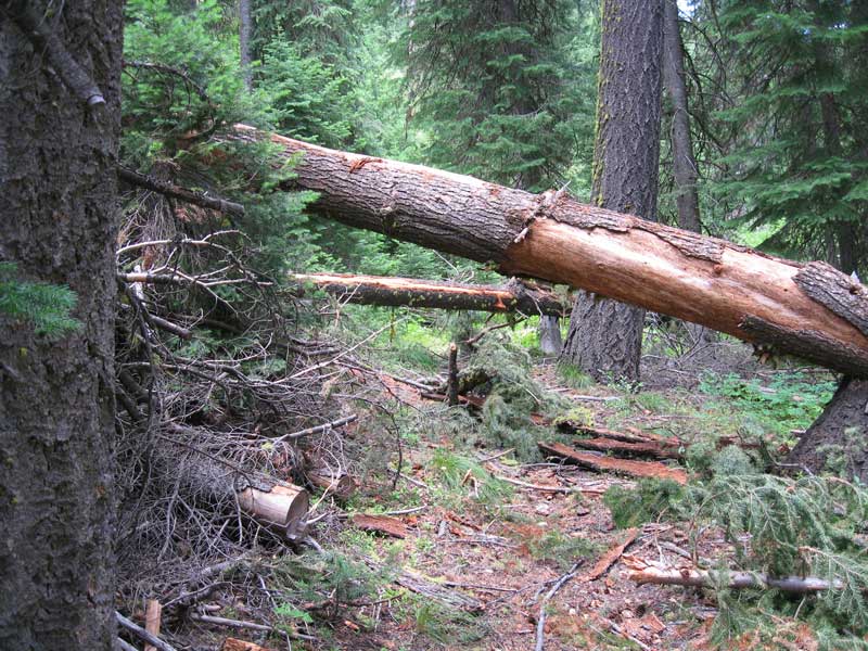
This portion of the trail has some obstacles to contend with but nothing a regular out of shape guy couldn’t handle. These obstacles were some pretty large downed trees laying across the trail. I doubt any motorcycle could make it down the trail, however.
Campo Creek was a rather small stream on the day I was there. The parts I saw where less than 10 feet across with depths ranging from a few inches to maybe 1 foot deep. Again, dense brush and bramble sheltered the streambed pretty well. I cannot imagine there will be any water in this stream by mid-September or even earlier. You get to cross Campo Creek once, but you’ll stay dry.
The End and Heading Back
This portion of FSR #172B ends at FSR #170L which would allow you to extend this hike much further. I suspect 170L doesn’t get much traffic so it might be worth it to continue heading north for a few miles on this road.
At the intersection of NFS Trail 172B and 170L
Heading back, you get some good views of what looked like the southern portion of the Trinity Mountains. There was also an abundance of wildflowers but most were a week or so past their prime. Still, quite beautiful.
Who Should Take “The Whiskey Jack Hike?
Let’s face it, I’m getting older and 10-20 mile day hikes are not going to be on my agenda any time soon. So any person in reasonably good shape could easily make this hike. If you are slightly or more out of shape, you’d enjoy this hike and could turn around anytime you wish.
According to my GPS and Google Earth, I hiked 4.75 miles total with a 1,600-foot elevation gain/loss. I could have gone further along FSR # 170L but there was no water to be seen for my dog and it was getting hot. Yeah, I worry about this dog but probably don’t need to.
There was a fairly large population of deer/horse flies and mosquitoes to contend with but nothing out of the ordinary for an Idaho mountain hike.
This was a great hike and I will be looking forward to doing this hike in future years … Maybe 2019? year.
Originally published on July 18, 2011.
Edited on republished on May 4, 2019.