
This July 2011 gold panning trip turned out to be a great day hike on a dirt road (NFS Road 170) that follows Spring Creek and the Johnson Fork near Featherville, Idaho. I walked almost 6.75 miles in mid 80 degree temperatures but you could easily add or subtract mileage on this “out and back hike” if you were to get up there. The scenery, weather and solitude made for a memorable day on the trail.
Getting There
NFS Road 170 begins where Spring Creek dumps into Trinity Creek on NFS Road 172 or Trinity Mountain Road northwest of Featherville. To get on Trinity Mountain Road you need to turn north off the Pine-Featherville Road just before entering the western portion of Featherville proper. The coordinates for this turn on to NFS Road 172 is 43.605535°, -115.266827°.
Stay on NFS Road 172 for approximately 3.5 miles and start looking for a place to park and the northward turn onto NFS Road 170. I don’t think there are any good places to park along Spring Creek/NFS Road 170 unless you head about ½ mile up the road.
The Hike Along Spring Creek / NFS Road 170
NFS Road 170 heads to the north or northwest and gradually climbs in elevation. It follows Spring Creek for the first 1.75 miles. Then it followed “The Johnson Fork” for the rest of my hike. The creek was flowing pretty good for an early July day but the streamflow is definitely decreasing. There are actually little sandbars forming in a number of places on the creek.
The Sandbars of Spring Creek
 |
| From Spring Creek or NFS Road 170 Hike and Gold Panning Trip |
The mountains and nearby hillsides were extremely green but things are starting to dry out up in the Boise National Forest. I was amazed watching my dog running full bore down the road at just how much dust she kicked up…not that this is proof of how dry it’s starting to get.
Overall, NFS Road 170 is suitable for any type of vehicle but there are a few places were downed trees narrows the available road width to the “just barely makeable” category for larger trucks. In any case, it’s a wide open and very easy walk.
Is There Gold in This Creek?
 |
| From Spring Creek or NFS Road 170 Hike and Gold Panning Trip |
Gold Panning the Creeks
I tried my luck at gold panning in both Spring Creek and the “Johnson Fork” during this hike. There was only one place where I panned up some black sand and possibly some color in the Johnson Fork. It wasn’t really worth exploring any further but getting down into the shade and close to the cool stream during the heat of the day was refreshing.
As I have found during every trip to pan these types of small creeks, the deer flies can get bad. At one spot my panning technique was the “continuous swirl and swat” method. I also learned that my dog Addie is a horrible gold panning companion.
I’ll come right out and say that Spring Creek and the Johnson Fork don’t have much potential for a recreational gold panning trip but your mileage may vary. Give it a try and let me know what you find. I still had fun and it’s a good way to refine your gold panning technique.
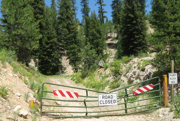
Learning the Ways of Closed Roads
My original plan was to hike NFS Road 170 and then head up NFS Road 170B. 170B heads uphill but eventually intersects and follows Spring Creek again. This road was closed on the day I was out there with a gate blocking access to it.
Yes, I know hiking on closed roads is permitted but the lack of water for my dog was a concern. I’ll be back to hike that section in the future.
This was not the 1st road I have found to be closed but it could have been a big disappointment had I been on my ATV or trying to drive my truck on it. Big lesson learned is that I really need to do some research if I intend to use my ATV. The Boise National Forest Service office in Mountain Home should be able to offer better guidance as to what roads/trails are closed.
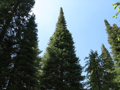
Solitude, Towering Pine Trees and Scenery Awaits You
 |
| From Spring Creek or NFS Road 170 Hike and Gold Panning Trip |
These closed roads and trail can also be used to the “hikers advantage”. I will be researching these types of closed trails. They are perfect places to hike when trying to find complete solitude. And an old closed road is certainly easier to walk on than some of the highly rutted hiking trails I have been on.
Where, Why and How?
– Coordinates at the trailhead for NFS Road 170 (roadhead if you will): 43.630485°, -115.312045°
– Coordinates for the closed NFS Road 170B: 43.660556°, -115.334592°
– Distance from Mountain Home, Idaho to the trailhead: 65 miles with only 3.5 miles of dirt/gravel road.
– Topo Map for this hike: The 1:24,000 Rocky Bar quad.
– Why Hike It: It was a beautiful hike that is easily accessible and suitable for the less experienced and even the most experienced day hiker.
– The Johnson Fork Creek? I’m kind of clueless about the name the “Johnson Fork”. Normally it would be a fork of some other creek. So, until I’m educated on this, it remain “The Johnson Fork” of no other creek just as all my topo maps indicate.
NFS Road 170 near Featherville
 |
| From Spring Creek or NFS Road 170 Hike and Gold Panning Trip |
Comments
Looking for comments ONLY from people who have interest in hiking, gold panning or those who like to or would like to get out into the great outdoors. If you fit any of these categories then leave a comment, question or remark.
