
Click to see a larger photo
Saturday May 7th, 2011: Last weekend I was out in the Long Tom Reservoir area (see this post). Today, I decided to head down to the reservoir to check it out. This wasn’t Plan A for the day but the rains overnight was sure to make the original hike to Wilson Flats a washout. The walk into Long Tom along the Reservoir Road was muddy and “puddley” in places.
How to Get to Long Tom Reservoir
Highway 20 north of Mountain Home, Idaho take a left (north) on the Prairie Cut-Off Road/National Forest Service Road 131. Travel about 2 miles on this gravel road and turn left (west) at 43.283791°, -115.537994°. The Long Tom Reservoir Road isn’t really suited for passenger cars and 4 wheel drive would be highly recommended at least during wet weather. The road to Long Tom is a rough and tough 2 miles. I parked on the Prairie Cut Off Road and hiked in from there.

Click for larger picture
The Hike into Long Tom Reservoir
The hike was quite easy considering it’s all dirt road. But you can go off-trail in spots to get some overlook scenery in places before getting to the lake. Because of the rains on Saturday morning, the small intermittent creek along the road actually had water flowing down the canyon. My dog enjoyed a few dunks and drinks but then again she is more adventurous than I am. For the most part, the hike is all downhill.
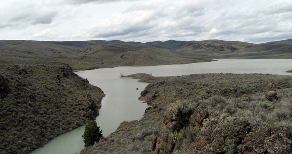
What I Saw
This hike is in the typical sagebrush sea as it descends into the Long Tom Basin. The hillsides contain some cool looking hoodoo rock formations. I was surprised by the depth and extent of the Spring Creek canyon on the south side of the reservoir.
Sign from deer/elk and coyote were plentiful while walking the entire length of the Long Tom Reservoir Road. I saw plenty of what I’m pretty sure were chuckers, as my dog Addie flushed many of these birds from the sagebrush. There were plenty of song birds hanging out along the road too.

Click for a bigger photo of the big rabbit guarding Long Tom
The main animal that was absent from this hike was the “human”. And likely because there were no people around, there was very little trash seen during the entire hike. Maybe because it was so early in the year or the road in wasn’t vehicle friendly? In any case, there was one ATV track into Long Tom and little other evidence anyone had been down the road.
This area really isn’t a place to rock hound. I saw very little of interest with the exception of some orange/brown rocks that could just as easily been chips from a brick. But who knows, there might be a gold vein or gems lying just over the next ridge.
A Video from Around Long Tom Reservoir and from Dirt Road (2:21 long)
The Statistics
Road Miles from Mountain Home: 18 miles
Gravel Road Mileage: 2 miles
Hike: 4.96 miles
Elevation Gain/Loss: 816 feet
Link to 6 Photos: https://picasaweb.google.com/tim.bondy/LongTomReservoirOnMay7th2011?feat=directlink
Open Street Maps Map of the Long Tom Reservoir Area:
View Larger Map
Comments About Long Tom Reservoir
You can easily leave a comment about this or any story on the BondyWeb.Com website. Why not let the readers of this website know what you think of this area or ask some questions. I won’t bite you unless you leave some stupid message.
