Hiking, mines, rock hounding and cool geology in the Owyhee Wilderness

Sunday April 10th, 2011 turned out to be a great day for a hike in the Owyhee Mountains. Temperatures were near 50 degrees and the winds were relatively mild. The ground was drying out nicely but there were a few muddy spots that needed to be avoided.
Where was the Hike
Head south on Mud Flat Road near Grand View to the ~4,700 foot level found at 42.743393, -116.310726. From this spot you head east-south-east, on foot, as this part of the Owyhee’s is now “Wilderness”. Keep on hiking until you run out of energy or reach your destination. Mine was Peak 5445 and it was a relatively easy hike.

Wilderness and Some Old Mines
When I planned this hike a few weeks ago my plan was to hike into Perjur Canyon/West Fork of Shoofly Creek. I knew I’d have to avoid some private property and hiking up Peak 5445 allowed me to do this. But then I discovered there were 7-8 old mining claims around the peak so these became my goal. I certainly cannot imagine gold or silver mines in this area due to the geology of the area and this aroused my curiosity. Again, this area is either private property or wilderness so you have to respect the rules/laws out there.

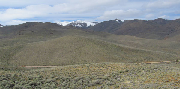
The Views
The views in this area are quite expansive. From the top of Peak 5445 and even at lower levels one can see the snow cover Bald Mountain and the huge ridge called Rough Mountain. The view also extends over the Snake River Plains and into the Boise Mountains. To the east is the relatively shallow Perjur Canyon. For the typical Idahoan, these types of views are normal but for folks that are stuck in the Eastern US, these type of views are rare.

Interesting Geology
First off, I only got to 2 mine sites and found nothing to get excited about. The rocks around them looked exactly the same as the ones seen during the whole hike. Maybe these old mines were underground and the source rocks buried?
On the other hand, the geology on the north side of Peak 5445 is quite interesting. I found one golfball sized “agatized rock” that was quite unusual. This was the only one I found like it though. The real cool geology was in the rock faces were some portions were obliviously twisted and tortured in the long distant past.
Location of Peak 5445
– 60 miles from Mountain Home.
– Only 6 miles of gravel roads.
– Owyhee Wilderness starts on the east side of Mud Flat Road.
– Peak 4554 is about 0.6 miles from Mud Flat Road with a short steep pitch near the top to climb.
Links to More Information
– An 8 Photo 160 Degree Panoramic Shot: http://cid-4d25e44b90ad42da.photos.live.com/self.aspx/Idaho%20Panoramic%20Photos/peak-5445-owyhee8x160.jpg
– More pictures from this hike: https://picasaweb.google.com/tim.bondy/OwyheePeak5445HikeAndRockhoundingTrip?feat=directlink
– Map to the area: http://goo.gl/maps/WA8s
