Click image for bigger picture
Hike Taken on February 13th, 2011: This close to Mountain Home, Idaho hike to well known geographic/geologic feature was most excellent. Covering just 3.1 miles and about 708 foot elevation gain/loss turned out to be a perfect Sunday day hike.
It was a warm and non-windy day in our area with my truck thermometer showing 54F when I left Mountain Home. The quick 30 minute/11 mile drive to Hot Springs Road and where I parked was easy on the budget. The last time I drove down this gravel road just northeast of Mountain Home it was quite muddy and slick. But on Sunday February 13th, the road was dry as was the little parking area I found ( 43.183847, -115.547574).
The Hike To Teapot Dome
The hike started on a dirt road heading due east towards the long and narrow free standing ridge line more commonly called Teapot Dome. The first portion was flat and somewhat muddy but once we started heading up the smaller peak (Pre-Tea) in front of the main ridge, it was dry and the scenery improved.
From on top of Pre-Tea ( 43.181464, -115.534761) you get a good view of the surrounding countryside. Water features such as the “Keith” and the “John Hoffman” reservoirs that I didn’t know existed just 2 months ago are easily seen. The Mountain Home Reservoir and the City are also seen to the west from this minor peak. And all of this can be reached from a dirt road that gradually fades into nothing but a faint trail. Not that I advocate trying to reach this self-name Pre-Tea Peak by truck but it certainly makes the hike up much easier when using an existing trail.
I continued east down into a very minor saddle between Pre-Tea and the Teapot Dome ridge. Heading up the Teapot Dome portion gets rather steep and somewhat rocky. The grade I hiked according to my GPS unit was between 40% and 48% . All the rocks along my hike were just boring old rhyolite but on occasion you find a small piece of bright white quartz. What’s up with that?

Click image for a very large version of this picture
On Top of Teapot Dome?
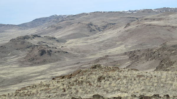
O.K., I never made it to the top of or the highest elevations of Teapot Dome. I hiked up the northwest flank of the mountain and made it to the 4,441 foot level ( 43.180827, -115.527576). The true peak was about 0.7 miles away and 300 feet higher. But the view from my vantage point was most excellent. One can see for miles and miles in all directions from there. The Bennett Hills escarpment is quite dramatic and has a prehistoric look to it.
Where the Deer and Antelope Roam
From “Pre-Tea and all the way to the 4,400 foot mark of Teapot Dome was littered with piles and piles of elk, deer and/or antelope pellets. This had to be the first time I’ve seen more wild animal poop than cow patties. I even saw a pile of what I suspect was wolf poop but who know what it was.
Video from This Hike
I took a video from the high point of my hike on Teapot Dome. Watch this 2 minute show of the scenery so you’ll know what to expect when you make this hike.
Link to YouTube Video: http://www.youtube.com/watch?v=5jpWbqzPdzY
Here is a link to 7 pictures of the I took on my Teapot Dome Hike: https://picasaweb.google.com/tim.bondy/TeapotDomeHike?feat=directlink

Click image for a bigger picture
Why I Liked This Hike
This was one of my most favorite hikes I’ve taken in the last year.
- While it’s not one of those “wilderness, get away from it all hike” it certainly was a very scenic and budget conscious outing.
- Clean landscape. No trash or signs of humans once I left “Pre-Tea Peak”.
- Prehistoric landscape.
- Way cool geology up close and personal.
- The vistas and long range views are amazing.
- My dog behaved the entire trip from door to door and I found out she really likes climbing rock faces/cliffs.
Comments?
Leave a comment about this hike and if you know of any other hikes close to Mountain Home, please let me know. I really like well thought out comments and/or questions from people who have similar interest


