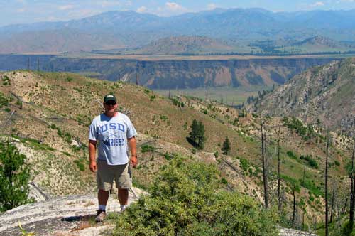
We were looking for a “close to home” rock hounding adventure for this weekend and we decided on a trip into the Danskin Mountains just north of Mountain Home, Idaho. The Danskins are not known for their abundant gem quality rocks and I doubt many collectors even bother heading into this area. While researching our trip, we found references that said the Danskin Mountain are a sterile portion of the Idaho Batholith. We didn’t let this little piece of research scare us away and neither should it scare you away from any part of Idaho in pursuit of cool and fascinating rocks, gems and minerals.

Tim with Prairie, Idaho in the distant background
The Danskin route we took once we parked the truck and rolled out our Arctic Cat ATV was National Forest Service Road (NFR) 167 to NFR 192 and then up NFR 325. From the map work and research I did, I know there was some old mining claims from the 1980’s starting at the intersection of NFR 192 and NFR 325 road and then all along the lower portions of NFR 325. And sure enough, the rocks along NFR 192 started changing from your basic lava rocks to quartz and feldspar rockiness and this is always a good sign when rock hounding.
What We Found
At the top of a ridge where NFR Road 325 starts heading south, we found some awesome views of the “Prairie prairie” above the South Fork of the Boise River canyon and surrounding mountains. A magnificent view can be had from the high point of 5,256 feet along this mountain. We named this long but prominent ridge line “Devils Hole Mountain” taken from the creek name in this area. My story, my right to give the mountain any name I choose…Right?

Just some cool looking rocks we found on Devils Hole Mountain
As far as rock hounding finds? We found a lot of cool looking rocks along NF Road 325. Most of the rocks are a conglomerate of feldspar, quartz (some small crystals), mica and opal. We brought home some very cool looking rocks but nothing a serious collector would get excited about. I suspect a person with lots of energy, a hammer and chisel and patience would uncover some small gem quality specimens.
Getting There and Tools to Find Devils Hole Mountain Rock Hounding Spot
Coordinates: 43.461654, -115.702329
Tools to find this spot: Google Maps will work but Google Earth is a much better program and it’s free.
Road Conditions: Forest Service Road 167 to the intersection of Road 192 is an easy and semi smooth gravel road. Once you start heading north on NF Road 192 you’ll want to either walk, ATV or beat up your 4-wheel drive truck at a speed of 10 mph or less. When you start up NF Road 325, you’ll not want to be in any vehicle as it’s rough, steep in spots but an ATV or motorcycle works just great.
Thanks for visiting and commenting on this outdoor article.
Tim Bondy
The Bondyweb.Com author

