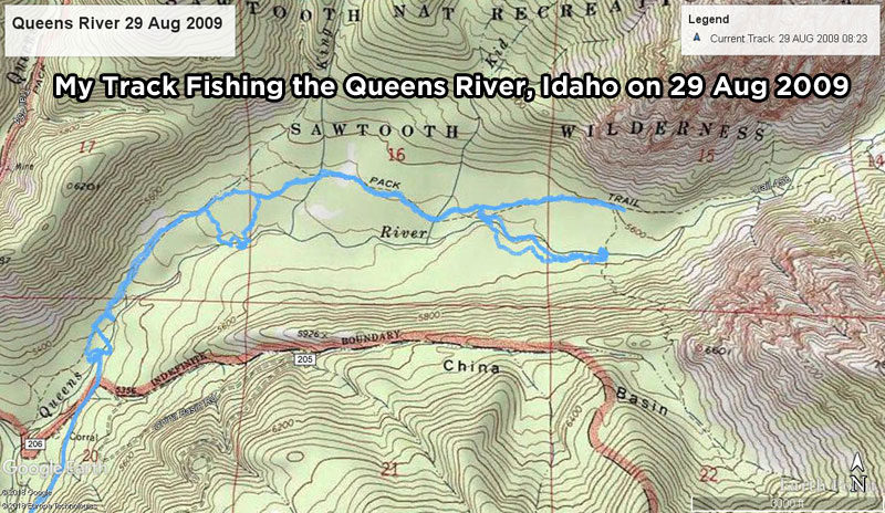
(Updated on May 24, 2019 / Author: Tim Bondy) Saturday, August 29th, 2009 was “The Queens Day“. I planned to hike and fish along the Queens River in the Sawtooth Wilderness near Atlanta, Idaho. I got out of the house early (for me at least) and headed up Highway 20. and eventually to Rocky Bar where I’d park the truck and unload the ATV.
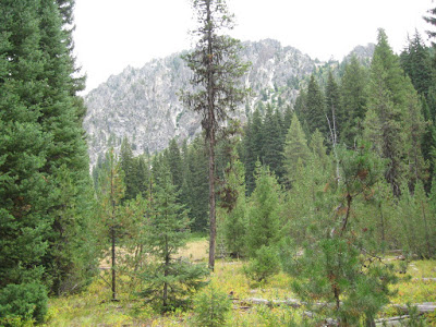
The Sawtooth Mountains Track to the Queens
The temperature when I left the house was a sticky 77F and dropped to 59F near Rocky Bar where I parked the truck and unloaded the ATV. The ATV trip up and over James Creek Summit and to the Sawtooth Wilderness gateway was very nice. I saw numerous deer, some with respectable antlers but most were does.
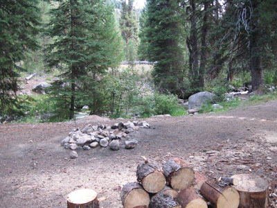
I decided to park just off China Basin Road (a.k.a Forest Service Road 206) and hike in from a little deeper into the wilderness instead of from the trailhead. What I didn’t expect to find was a short dirt road leading right down to the Queens River and a nice 5 site campground. I parked the ATV and headed off trying to find a place to get on the north side of the river where the hiking trail is located. The Sawtooth Wilderness boundary is the Queens River at this point. It took some doing but I finally found a log to scramble across and thus keeping my boots dry as I entered the designated wilderness area.
Into the Sawtooth Wilderness to Fish the Queens River
Once I found the Queens River Pack Trail, I headed to the east while watching for places to fish. I fished a few holes but didn’t have any luck catching anything. Not that there were not any fish, as I regularly “hooked em” but couldn’t seal the deal. Either my skills have eroded in two weeks or the fish in the Queen are more adept at shaking my treble hook.
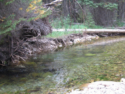
I decided to get off the beaten track and head off trail towards the river at some an arbitrary spot. My handy GPS unit showed it was only 1/5 of a mile to the river. Mileage can be quite misleading when you run into the dreaded “marshy area” bordering the river. I’d say the 1/5 of a mile turned into over ½ mile of rough going. But once I got to the water’s edge, I started catching trout … Mainly rainbows.
Eventually, I started back to the trail by heading east. The trail along this portion of the wilderness is quite nice, easy to follow with an easy going gradient (flat). There were a few nice meadows I hoped to catch sight of some wildlife but never saw anything other than some birds.
The Perfect Fishing Holes on the Queens
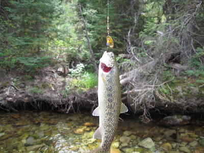
At about the 2-mile point, I spotted a nice pool not far off the trail. I headed down to a nice river rock beach and started fishing. This particular section of the river is what I called the perfect spot. With about 4/5 of a mile of alternating shallows/riffles and small pools to fish, I spent a long time enjoying myself. All the trout I caught were small except one biggish one that taped in at about 10 inches. Map coordinates of this section are 43°51’17.75″N / 115° 9’10.73″W and upstream.
The Hike Gets Tough Again
From this section of the river, I decided to continue upstream walking mainly in the river…and over, under and through numerous deadfalls, logjams and marshy areas for about ½ mile. The fishing was quite tough as I had to deal with very small casting areas. Small trout live in this section of the Queen. I finally had enough of this watery trail busting and decided to try my luck on the south side of the river.
Heading Back to the Queens River Pack Trail
Once back on dry land, the hike was way easier as I headed east along the river. Unfortunately, the river becomes less fishable from this spot ( 43°51’14.33″N / 115° 8’58.56″W ) but the scenery becomes more dramatic also. I decided to head towards a marked trail that should cross the river and lead me back to the Queens River Pack Trail. The GPS unit indicated it was only about 3/10 of a mile upstream and I headed out. I scared up some type of animal during this period but never caught even a glimpse of it as it headed further south away from me. Does bigfoot live around here?
I found a faint game trail that lead me to a good place to cross the river. I crossed the Queen and stood on the north side looking for the trail that would lead me back to the Queens River Pack Trail. Well…this portion of the trail seems to have vanished as it heads north from the river.
Where did the Queens River Pack Trail Go To
Trail #469 on the Forest Service maps may exist but I certainly couldn’t pick it up on the north side of the river. I headed back the way I had come.
I went back to the easy fishing section of the river for a few dozen casts and to put my hiking boots back on. By this time my old canvas sneaker/fishing shoes were starting to blister my feet anyway. With my comfy hiking boots on I had to find out if trail 469 really existed. So I headed east on the good old pack trail in search of a trail that is gone forever. I stood on the exact spot the trail was supposed to intersect the Queens River Trail (using my GPS unit) but there was no sign of it.

It was getting late so I headed back west towards my ATV. This portion of the hike was quite enjoyable as I could just enjoy the surroundings and not worry about finding a “mythical fishing hole“.
Notes of Interest
- I earned (IMHO) every fish I caught on this trip. I also enjoyed almost every minute of the trip except a few point in the marshy sections. It was rough going in spots but well worth getting off the beaten track.
- Maps are a great way to research a trip like this. Don’t expect every trail on them to exist.
- This is a wilderness so care must be taken that you don’t get hurt…especially if you are alone. There are some big creatures in these woods. I ran across bear scat and what might have been wolf scat. Unfortunately, I saw neither of these animals but I am hopeful someday I will come across either species.
- The south side of the Queens River is the “dry side”. If going off trail, I recommend tending on this side of the river. I’ll put this information in my cap for next years fishing trip to the Queen.
- My best guess is that one should not attempt this type of fishing trip until the river flow decreases. I’d say late July would be the earliest to go. The end of August may be a little too late as the flow was down too far in some section but I’m sure it allowed the marshy areas to dry out some also. Your mileage on this matter may vary, however.
Link to all photos from this trip can be found at https://photos.app.goo.gl/TP5NXxZ7uvdBq3cy5
Originally published on August 31, 2019. The story was edited to fix links and improve the readability of the story on May 24, 2019.
Thanks,
~ signed ~
Tim Bondy
Freelance Writer & Citizen Journalist