Saturday November 29th, 2008 seemed like a good day for a hike. I chose Doyle Mountain which is about 16 miles south of Oreana, Idaho. I’ve never been down this particular gateway into the Owyhee’s so I wasn’t too sure I’d even get close to my destination. I’ve heard the roads into the desert/mountains can be quite difficult to drive. Much to my surprise, the roads right to the foot of Doyle Mountain were pretty good.
Finding the Starting Point

My hiking style is rather loose in that I will decide on a goal (peak or landmark) but it really isn’t important if I make there. This type of hiking makes it easy to modify my plans as the conditions dictate. Because of this I don’t have research a hike very deeply either. Today I was
lucky and found a great parking spot at the foot of the mountain. I already knew I would be hiking cross country or in other words, there would be no trails to follow. My only guide would be a creek bed and what I assume was the the Doyle Mountain peak.
The Hike Up
I grabbed my day pack and headed up the creek bed I spotted earlier on my Google Earth program. The sagebrush was much thicker and taller than any I have encountered on any trip into the Owyhee’s. This could mean two things. Either cattle haven’t been grazing on this land or this spot gets more precipitation than other parts of this desert landscape. Well, cattle definitely have worked over this creek bed some as there were plenty of cow patties. But on the bright side, there were “bovine single tracks” I could follow up the mountain.

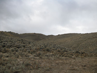
The first part of this hike wasn’t too strenuous or steep. But it didn’t take long before the going got steep and rocky. So, in addition to winding through chest high sagebrush, I had to deal with steep, rocky soil. This got the old blood flowing and the lungs burning. But when I’m hiking I’m rarely in a hurry as I like to stop often to look around. About half way up to what I thought was the top of Doyle Mountain, I took my first full sit down break. This gave me time to see were I came up the valley and to take in some of the scenery. Even at this mild elevation the view was pretty spectacular.
Doyle Area Geology
The geology of this mountain was completely different than hiking up a valley off Mud Flat Road last weekend. The rocks on the side hill were quite interesting with lots of granite and quartz with some common opal mixed in for good measures. As a semi-rockhound, I found this change quite amazing when I thought about the sterile geology of the area near Mud Flat Road. There were also two minor spring-like features in the creek bed I hiked up. One of these springs had some water seeping out of the bedrock but it was a little difficult to get a close up look as the brush and trees crowded around this wet area. The second spring was much drier in the places I could see but the vegetation was also much thicker. I’d say there had to be some water in there somewhere. Luckily I brought my drinking water with me.

I’ve heard that there are some rock drawing/petroglyphs in these parts so when I saw some larger rock outcroppings I hiked to them for a look around. I really wasn’t expecting to find any of these features but one never knows. On most of these rocks there is a goodly amount of moss growing (mainly on the north sides) that I found interesting. The moss is lime green and a color not normally seen in this high desert landscape.
Cow Patty Peak?

I pushed on to the summit only to discover I wasn’t even close to the top of Doyle Mountain but I was happy getting to this high point. I came to find out the true summit was two peaks to the west but they didn’t look quite as interesting as the peak I was standing on. I was quite shocked to see that many, many cows had beat me up to this peak. There were cow patties spread all over the summit and because I haven’t heard or seen anyone claim this peak, I will aptly name this peak “Cow Patty Peak”.
The wind on top of Cow Patty was blowing pretty darn hard so I headed down about 30 feet for the wind protection of a large rock wall. I was out of the worst of the wind and stripped off my shirt and sweater to let them dry out. I also sat down and ate my usual hiking lunch while overlooking the Snake River Valley and some higher peaks off to the south and west.
The Easy Way Down
As I sat on the summit of Cow Patty Peak, I plotted my journey down the mountain. The easier way down was by staying on the ridgeline just above the creek bed I climb up. I found my route down was quite easy as the sagebrush was much more sparse and of course the downhill gravity effects certainly didn’t hurt. I stopped on a number of occasions to look at the rocks I was walking on. There were big pieces of quartz in spots. Some pieces as big as a dinner plate. I suspect that the miners of old have picked through this area pretty good but I’d like to explore this area a little closer next time I’m up in this area.

Getting There
Head out of Mountain Home and go through Grand View. Take the Grand View/ Murphy Highway west. About 5 miles west of Grand View you will head south on Missile Base Road. This gravel road is suitable for a regular passenger car and I suspect this road changes name to Birch Creek Road. At the intersection of Birch Creek Road and the Poison Creek Cutoff Road you continue straight ahead. At this point the road turns into what I’ll call BLM Road 3724 and the gravel road turns into a dirt road.

While a regular passenger car could navigate this dirt road, I’d watch the weather closely. If there was any rain during the past few days, this road would likely become quite bad. You stay on BLM Road 3724 for about 6-7 miles until you see a small turnout with a water trough.
Mileage from Mountain Home: 49 miles
Mileage from Boise: 88 Miles
Seasonal Hike?
I’d say there is a narrow hiking window for hiking up Doyle Mountain. That would be after the snakes have gone into hibernation. Look at hiking this area in the late fall and early winter time. I’d stay away from this hike if there was any snow on the ground as it’s just too steep to make for an enjoyable hike in the snow.
