Back on July 18th, 2009 we explored the South Fork of the Boise River on our ATV/4 Wheeler. This area was new to the Bondyweb (Tim and Toni). Our real destination was to ride out to the headwaters of the South Fork of the Boise River. Our best guess is the headwaters of this famous river is located at the confluence of the Ross Creek, Steep Creek and and Johnson Creek or at roughly 43.778518° / -114.928084° .
 |
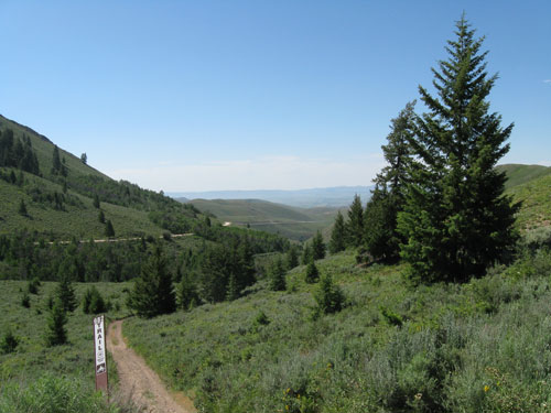
Near the top of Couch Summit outside of Fairfield Idaho
We loaded up our ATV and headed towards Fairfield, Idaho and then up Soldier Creek Road to National Forest Service Road 94 where we would park to start the ATV portion of the trip. There is a good place to park below Couch Summit at 43.477390° / -114.809824° . From Couch Summit we followed the well maintained dirt road along Little Smoky Creek to Fleck Summit. Forest Service Road 12 follows the South Fork of the Boise River and continues along Road 79. We never made it to our destination but stopped about 6 miles short of the headwaters of the Boise River.
What We Discovered
The route from Couch Summit to the confluence of Little and Big Smoky Creek is a well traveled road. We encountered many people on this beautiful day traveling in ATV’s, motorcycles, trucks and cars. At some points, the road was pretty darn congested. Stopping to wade in Little Smoky Creek for just a few minutes resulted in a thick covering of dust as the vehicles went past.
 |
This intersection is along Big Smoky Creek
From Big Smoky Creek to Fleck Summit and down to the South Fork of the Boise was a nice ride with only a few people around. From the bottom of north side of Fleck Summit and along the Boise River there was quite a bit of private property and vacation homes/cabins. This kind of surprised us to see so much private property.
 |
Butterflies were everywhere along this logging road near Elk Creek Campround
Since we started ATVing, we had become accustomed to relative solitude on the Idaho dirt/gravel roads and maybe a little less groomed roads at that. So when we came upon a The Elk Creek campground about 6 miles short of our destination we decided to stop and find an alternative route. What we found was what I think is an old logging road heading east up into the mountains. This road is not on any maps I looked at but it roughly follows Headquarters Camp Creek. The road was rough and it provided us with the type of solitude we are use to and great scenery. I took a video from one portion of this road.
Location of video is 43°41’57.33"N / 114°53’6.62"W
Overall, we had a great time and explored may miles of Idaho "backwoods" on this warm and sunny July day. This trip opened our eyes as to just how many people like to get out of the city and enjoy our famous mountains and forests.
NOTE: I use the word "headwaters" as a place where the South Fork of the Boise River is no longer called this. A look at any map will show that feeder creeks like the Ross Creek Forks or even Johnson Creek could extend the word "headwaters" a considerable distance.