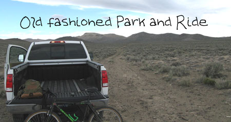
March 28th, 2009 found me back in the Owyhee Mountains. As usual, I have a very loose plan of mountain biking up a dirt road/jeep trail in Vinson Wash. With my GPS unit programmed for the trailhead just off the Poison Creek Cutoff Road I pull out of Mountain Home, Idaho at 1:00 PM. 50 miles later I’m pulling into my own private "park and ride" lot in the Owyhee’s.
 |
With the temperatures hovering around 57F and a light swirling breeze I take off on a trail I think is called Twentymile Gulch. The double track is in pretty good shape…much better than the bike rider, and I have no problems negotiating the ruts and rocks of the trail. The first interesting thing I come upon is a large white PVC pipe sticking out of the ground. This of course is a mining claim. I dismount the bike for a closer look at the area. I’m sure the owner of this mining claim knows what he is after but I don’t see anything that would indicate he is sitting on anything that will make him rich.
 |
It reads:
Common Corner GRV
Lode Claim Number
436-471
The trail crosses quite a number of washes and intermittent stream beds. I take a short break from the bike to walk up one of these washes. This one particular wash has been frequented by ATV’s as evidenced by the numerous tire tracks that run along the dry streambed. I keep my eyes on the ground for interesting rock but as usual, all rocks I see fall into the "leaveitrightthere" classification. I’m certainly glad I didn’t try to follow my motorized friends up this wash on my bike. The sand is quite deep in a lot of places and this old guy wouldn’t be able to power through it. But I am finding that short hikes in the washes of the Owyhee’s are quite enjoyable.
 |
Back on my bike, I continue up the double track alternately scanning the ground for rocks and taking in the mountain/desert scenery. There is just a ton of things to see in this region and that is why I love it down here. As I said, my plans are not set in concrete so when I come across an intersection, I stop for some water and a look at the two roads ahead. Antelope tracks cover the ground all around this area and they seem to be heading south up the road to the right. I walk up the trail to the left and find some interesting rocks laying on the road. This road was considerable rougher than the one to the right so I decided to take the easy path this time. On my way back to my bike I explore a small area that is devoid of almost all plant life. I am very surprised to find 3 patches of "prickly pear cactus" growing out of this rocky soil.
 |
Owyhee intersection? No streetlights!
With my decision made to head up the easy trail, I set off following the many antelope tracks. This portion of the road is thankfully smooth, soft and easy to ride. My legs muscles and lungs need a break from the rougher sections I previously said "were in good shape". With all the animal tracks on the road I figure there is a slight possibility I might see some deer or antelope. I keep my eyes on the horizon as much as possible. As I approach the top of a hill, I see flashes of white moving around. I get off my bike, get my camera ready and slowly walk towards the movement in the distance. There are about 10 antelope ahead of me and I take some pictures. These animals must have extremely good hearing because as soon as I noisily zoom in with my camera, the antelope take off to the west. I keep watching and am rewarded by the sight of a herd of antelope fleeing for their lives up into the mountains. Quite a sight to watch and made the whole day worthwhile.
 |
Insert herd antelope
Animals of the Owyhee’s
On this trip I saw about 10 black-tailed jackrabbits, 10 bazillion flies, coyote poop and of course the majestic pronghorn antelope. During my five off trail mini-hikes I wonder how many snakes I didn’t see.
Map of Trip
View Larger Map
Details
Location: Owyhee Desert/Mountains south of Mountain Home Idaho
Date/Time: 1:50PM until 4:30PM on March 28th, 2009 Author/Photographer: Tim Bondy
Distance to Poison Creek Cutoff Trailhead: Mountain Home is 46.4 miles away and Boise Airport is an 85.9 mile drive.
Road Condition to Trailhead: Paved except the last 2.6 miles (Poison Creek Cutoff). This small section of gravel road is suitable for any kind of car.
Slideshow Address: http://picasaweb.google.com/tim.bondy/VinsonWash28Mar2009?feat=directlink with 19 photos.
Sorry about writing the narrative in a "first person personal" style.